
FROM ONE TO FIVE?
Back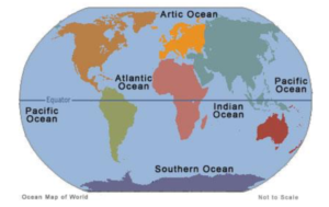
Ninety Seven (97%) percent of the water covering the more than 70% of the Earth is oceans. According to data provided by the World Resources Institution (WRI), forty (40%) percent of the world’s population lives in the coastal areas surrounding this body of water.
Geologically, an ocean is an area of oceanic crust covered by water. Oceanic crust is the thin layer of solidified volcanic basalt that covers the Earth’s mantle. The continental crust is thicker but less dense. From this perspective, the geologists concluded that the earth has three oceans: the World Ocean, the Caspian Sea, and Black Sea. The latter two were formed by the collision of Cimmeria with Laurasia. The Mediterranean Sea is at times a discrete ocean, because tectonic plate movement has repeatedly broken its connection to the World Ocean through the Strait of Gibraltar. The Black Sea is connected to the Mediterranean through the Bosporus, but the Bosporus is a natural canal cut through continental rock some 7,000 years ago, rather than a piece of oceanic sea floor like the Strait of Gibraltar.
The three great oceans of the world are in order based on size; the Pacific Ocean, the Atlantic Ocean and the Indian Ocean. The ocean’s greatest known depth is in the Puerto Rico trench, 28,374 feet below the ocean’s surface.
The borders of the oceans are the limits of the Earth’s oceanic waters. In 1928, the first edition of the International Hydrographic Organization’s (IHO)
WORLD OCEANS 1
Limits of Oceans and Seas publication included the Southern Ocean around Antarctica. The Southern Ocean was delineated by land based limits; the continent of Antarctic to the south, and the continents of South America, Africa, and Australia plus Broughton Island, New Zealand in the north. The detailed land limits used were Cape Horn in South America, Cape Agulhas in Africa, the southern coast of Australia from Cape Leeuwin, Western Australia, to South East Cape, Tasmania, via the western edge of the water body of Bass Strait, and then Broughton Island before returning to Cape Horn. Thus, the definition and number of oceans can vary depending on the adopted criteria.
The northern limits of the Southern Ocean were moved southwards in the IHO’s 1937 second edition of the Limits of Oceans and Seas. The Southern Ocean then extended from Antarctica northwards to latitude 40° south between Cape Agulhas in Africa (long. 20° east) and Cape Leeuwin in Western Australia (long. 115° east), and extended to latitude 55° south between Auckland Island of New Zealand (long. 165° or 166° east) and Cape Horn in South America.
The Southern Ocean did not appear in the 1953 third edition because “…the northern limits … are difficult to lay down owing to their seasonal change … and according to the Hydrographic Offices who issue separate publications dealing with this area, nations were therefore left to decide their own northern limits. (Great Britain uses the Latitude of 55° South)”. Instead, in the IHO 1953 publication, the Atlantic, Indian and Pacific Oceans were extended southward, the Indian and Pacific Oceans (which had not previously touched pre 1953, as per the first and second editions) now abutted at the meridian of South East Cape, and the southern limits of the Great Australian Bight and the Tasman Sea were moved northwards to (long. 67° west).
In 2000 the IHO redefined the Atlantic Ocean, moving its southern limit to 60°S, with the waters south of that line identified as the Southern Ocean. This 4th edition of Limits of Oceans and Seas has yet to be published due to ‘areas of concern’ by several countries relating to various naming issues around the world. The IHB circulated a new draft of the 4th edition of the publication in August 2002, however there were still various changes, 60 seas were given new names, and even the name of the publication was
WORLD OCEANS 2
changed. A reservation had also been lodged by Australia regarding the Southern Ocean limits. Effectively, the 3rd edition (which did not delineate the Southern Ocean leaving delineation to local hydrographic offices) has yet to be superseded.
If and when adopted, the 2000 definition will be published, the 4th edition of Limits of Oceans and Seas, would restore the Southern Ocean as originally outlined in the 2nd edition, but subsequently omitted from the 3rd edition. In essence, the oceans boundaries between these regions have evolved over time for a variety of historical, cultural, geographical, and scientific factors. Although historically, there have been four named oceans: the Atlantic, Pacific, Indian, and Arctic, most countries, including the United States, now recognize the Southern (Antarctic) as the fifth ocean.
The U.S. Board on Geographic Names recognize the fifth ocean as the body of water extending from the coast of Antarctica to the line of latitude at 60 degrees South.